|
Field Names in Hertfordshire |
|
|
Field Names in Hertfordshire |
|
If you were a farmer you would clearly need a name for each field in order to tell your workers where to go and as a result all fields had names - some going back many centuries, and many will still be in use. Modern farming involves fields being merged, or taken over by housing, and the names are lost or used in other ways. For instance in 1937 my parents erected a house (where they lived when I was born) which was called Eylotts - after the old field name. Marlowes, the main shopping street of modern Hemel Hempstead, was also originally a field name.
However they are rarely recorded in easily accessible places for the genealogist. The names are not given on Ordnance Survey maps (even of the largest scale) and the only book covering Hertfordshire which mentions many names is The Place-names of Hertfordshire and this only lists some of the names that were recorded in Medieval times, and gives no idea of the locations within parishes. The following is an example from Kings Langley.
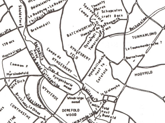
KINGS LANGLEY. Long Tags (cf. Tagges, Taggescroft 1437 Ct, Tagges land 1556 AOMB. Cf. Stagsend supra 36). From the TA we have Briery Fd (cf. Brierie croft ib.); Broad Fd (le Brodefeld 1382 Ct); Brook Fd (Brokefeld 1556 AOMB); Dell Fd (cf. le Dell ib.); Dellage Fd (Delledge ib., i.e. 'dell edge'); Heath Fields (cf. Richard atte Hethe 1437 Ct); High Fd (Highfeld 1556 AOMB); Kitchen Croft (Kitchin croft 1623 ib.); Lamb Croft (Lambe croft 155 I SidSus); Little Fd (cf. Litle croft 1556 AOMB); Long Fd (Longefeldes ib.); Nookerty is full of corners; Pear Tree Turrett (cf. Peartre croft ib.); Pedcroft (Petcroft 15th VCH ii, 235); Reddings (cf. le Ryding 1437 Ct, v. hryding); Round Fd (cf. Rounde crofte 1556 AOMB); Spring Fd (cf. le Sprynge 1413 Ct and spring supra 259); Winch Fd (cf. Winchcroft 15th VCH ii, 235, v. supra 24); Wood Fd (cf. Woodcrofte 1556 AOMB). The book Reconstruction and Measurement of Landscape Change includes a detailed study of the filed names for the parishes of St Albans (Abbey, St Michaels, St Peters and St Srephens) and the parishes of Redbourn and Sandridge. It contains very long lists of field names together with their sources but the precise locations of the fields is not given in most cases - although the following is part of the reconstructed map of medieval field names immediately round St Albans.
Many farms were part of large estates and in some cases detailed records may have survived - the following detail comes from one of the earliest surviving estate maps for the manor of Rothamsted, Harpenden:-
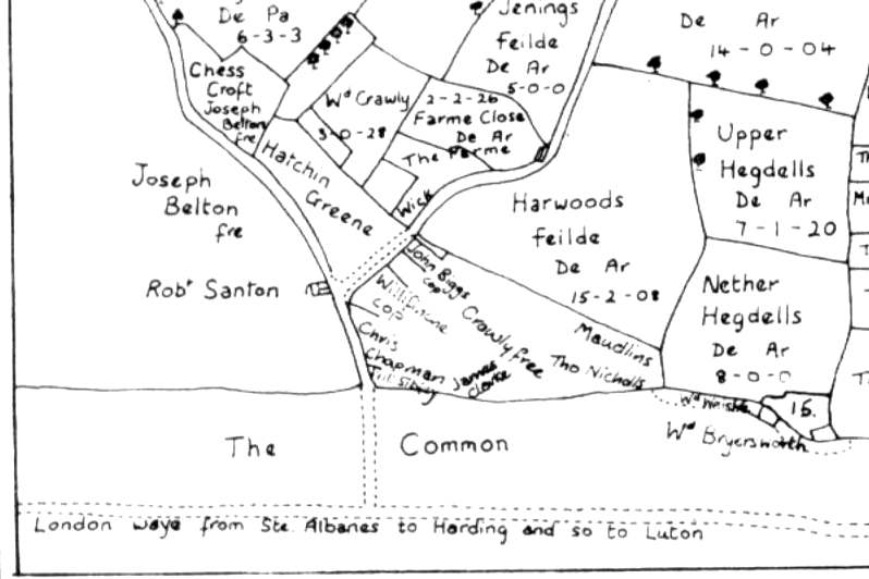
Redrawn from "Plot of the Demeanes of the Mannor of
Rothamsted" 1623 in Wheathampstead and Harpenden Volume II.
Many manuscript estate maps survive, and Catalogue of Manuscript Maps contains a list held at HALS in 1969 - more up-to-date details being available on their online catalogue. In many cases there will also be associated documentation, and old sales particulars can sometimes be a useful source. However estate papers may turn up anywhere - for instance the Lord of the Manor for Sandridge is Earl Spencer (brother of the late Princess Diana), who lives at Althop House and many of the estate papers are in the Northampton Records Office. However some of the old maps were sold and the earliest (from 1726) is in a bound volume of estate maps in the British Library. For this reason a search on Access to Archives can turn up useful information on Hertfordshire estate records held outside the county.
The most useful series of manuscript maps are the Tithe Maps which were drafted for Hertfordshire parishes between 1838 and 1851, All properties were identified in a separate schedule, with owner and tenant, and field names are often given. Three manuscript copies were produced, one for the parish clergyman, one for the diocese, and one for the Tithe Commissioners. In most cases the parish and/or diocese copy is now at HALS while the third copy is held at the National Archives. In addition, for some parishes, HALS holds Enclosure Maps, which can also be a useful source of field names.
Field names can be mentioned in many other places. Some local village histories may mention them - and in a very few cases may even have a map. There could well ne references in documents such as manorial rolls or wills (rarely with a map). It is always woth looking at modern place names where the name of a house, road, or even district could be that of a former field name.
And don't forget - if the land is still farm land the local farmer will have a name for it, which might be centuries old, and you could well discover other "lost" names over a pint in the local pub chatting with one of the older inhabitants.
If you can add to the information given
above tell me.
| September 2010 | Page Created | |