|
|
Reconstruction and Measurement of Landscape Change A study of six parishes in the St Albans Area Jonathan R Hunn TEMPVS REPARTVM, BAR British Series 236, 1994 Paperback, 30 * 21 cm, 346 pages |
 |

 This
detailed academic study examines the changes in the landscape around St
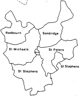
Albans from the Iron Age and Oman times through to the 20th century. It looks
at the parishes of St Albans, St Michaels, St Peters, St Stephens, Redbourn
and Sandridge. At first sight it contains few names of use to the family
historian, but it includes maps based on originals of each of the parishes at
various dates, and a large table of field names. As such it contains
references to many original documents which do include the names of land
owners and occupiers.
It is an invaluable source for information on the manuscript
maps of the parishes that have survived.
This
detailed academic study examines the changes in the landscape around St
Albans from the Iron Age and Oman times through to the 20th century. It looks
at the parishes of St Albans, St Michaels, St Peters, St Stephens, Redbourn
and Sandridge. At first sight it contains few names of use to the family
historian, but it includes maps based on originals of each of the parishes at
various dates, and a large table of field names. As such it contains
references to many original documents which do include the names of land
owners and occupiers.
It is an invaluable source for information on the manuscript
maps of the parishes that have survived.
See Field Names for a detail from the map showing known Medieval field names around St Albans.
There are web pages for St Albans, St Michaels, St Peters, St Stephens, Redbourn and Sandridge.