D.D. Cramb (geezeeer @t btinternet.com) of Borehamwood, Herts, says John Cramb was trading at No 4 High street Hemel in 1901 as a monumental mason, however the High St now starts at number 16 so where was no 4? I have been to the library looked in Kellys and also the book on the High St by the ex lady mayor but can find no ref to no 4. Local maps show that the High St extended down to where the Queensway now is, is this assumption correct? In an advert in the local paper for John Cramb 1901 there is a ref to masonry works Marlowes is there any information on this site. I have checked the 1901 census and find that they lived in Adeyfield but no house number.
The only reference to John Cramb I can find is in a Kelly's Directory of circa 1902, which recorded him as a private resident living at "Adey fields". An examination shows that there was only one other private resident, Jean Wilhelm Jollasse, living at "Adey fields" and a quick glance at the traders (not guaranteed to be comprehensive) showed Arthur Howard, market gardener, was there as well. A look at a contemporary OS map will show very few houses in the area - and if you looked at John Cramb's neighbours on the 1901 census I am sure your would find there were insufficient families at Adey Fields to justify numbering.
John Cramb
is not listed in Kelly's directories of circa 1899 and circa 1912 and is not listed as a tradesman in the circa 1902 directory.The road now know as Queensway is effectively a Hemel Hempstead New Town Road and the lower numbers of the High Street, in a wider stretch known as the Broadway, are now considered to be part of Queensway. The book you refer to is presumably "Times Highway", by Elizabeth Buteux, and there are several illustrations which are relevant and I give the page references below. I collected a lot of information about the area when I was researching the book "The London Gunners come to Town".
From trade directories and census returns, the first reference I have to the original "Number 4" was occupied by Englebert Kimich, watch maker, from 1878 and the building can be seen in the photograph of the Fire Brigade on page 31 of the book, with "KIM..." visible over the shop. A map of the area published in 1897 showing the fire station and the shop is on page 36.
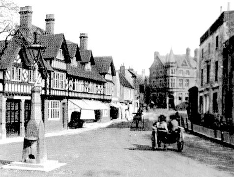
The Broadway about 1910 - Kimich's shop (No. 4.) has the nearest sun
blinds.
In about 1905 the shops and fire station were demolished and a new fire station and mock tudor shops were erected (picture page 32). It may be that the new Fire Station was No. 1 Broadway. The Kimich's continued their business in what were now No 2 Broadway with Mrs Isobel Kimich, milliner & ladies outfitter, and No 3 Broadway with Joseph Kimich, watch maker, whose daughter was a school friend of my mother. Joseph Kimich died in 1915 under tragic circumstances and the rumour at the time was that he has killed himself because Germans were being interned and he was frightened that he would be. (See "The London Gunners come to Town" for details.) See also Joseph Kimich's Advert.
There is little doubt in my mind that the Kimich's occupied No 4, High Street, in 1901. Joseph Kimich is listed in the 1901 census for Hemel Hempstead and if you look at the return you should be able to confirm that they were at No. 4 High Street.
I assume that your reference to 4 High Street comes from the advertisement you mention. Perhaps the Kimich's took orders for his grave stones or perhaps the space between the old fire station and the Kimich's house (page 31) was used as a display area for his stones.
The firm you mention in Marlowes may well have been Woodman Brothers. William Woodman, corn merchant and factor, had the Albion Steam and Water Corn Mills towards the south end of Marlowes in 1868. Subsequently the Woodman Brothers multiple directory listings includes Corn, Cake Coal & Cement & Builders Materials Merchants, & Marble Masons in 1890; Corn Millers, Cake, Coal Merchants and Monumental Masons in circa 1899 and simply Corn Millers, Cake, Coal & Builders Merchants in 1902. By 1914 they were simply Corn & Coal Merchants. Could it be that your John Cramb was their monumental sculptor and he parted company with them in about 1900.
January 2003
D.D. Cramb (geezeeer @t btinternet.com) of Borehamwood, Herts, says Further to my previous question about the Cramb of Hemel I have now found out that they lived in a house called The Orchard in the Adeyfield area is there any history of this house.
Have you looked at the 1901 census and contemporary Ordnance Survey maps, as I suggested earlier, and if so what did you find? The 1897 map for Hemel Hempstead (reprinted by Alan Godfrey Maps - so widely available, for instance from the Society of Genealogists) shows Adeyfield Farm and a house near the "Nursery". One of the nearest buildings, located at Wood End Lane/High Street Green, is called Hoblets Orchard - and I wonder if this is relevant. There is a good collection of large scale OS maps in the Hemel Central Library, and they also have a number of local trade directories. Your best bet would be to give them a visit.
April 2003
D.D. Cramb (geezeeer @t btinternet.com) of Borehamwood, Herts, says: I have just received some info saying that three of the Crambs I've ask you about before went to live in Tring in Grove Road at a house called Fort William. This must have been some time after 1901 as they appeared on the 1901 census in Adeyfield, these were Eliza, Jane,& Mary Cramb.
I am afraid there is nothing for Cramb in Tring (either Private or Commercial) on the Trade Directory between 1912 and 1937 (see archiveCDbooks). In fact there are only two houses listed for Grove Road in 1937, and as far as I can gather the road was still a country lane - with a few cottages (too humble for their occupants to be listed) near Grove Farm. Part of the terraced workmen's cottages at the New Mill end may have had a Grove Road address and perhaps one or two detached houses, also at the New Mill end, which I guess may have been 1930s. (I ought to know how old they are because in the early 1980's I viewed one of them with a view to purchase.) My impression is that housing development along the road only began after the 1939-45 war, and that nearly all the pre-war development of larger detached houses on that side of Tring was along Station Road. (One house on the corner of Station Road and Grove Road has just been demolished - and a 7 bedroomed triple garage property has been erected on the site at a reputed price of about Ł1,000,000, together with two 5 bedroomed houses.)
July 2003
Paul Finch (paul.finch @t
ntlworld.com)
writes your correspondent DD Cramb was enquiring about the orchard in Adeyfield.
I lived in Woodfarm road from 1956 until
1967, the old farm was still standing. The old gentleman who owned the farm
was a Mr Fisher (Fischer). I used to play in the orchard at the back of the
farm, he may well have been in his eighties then. I believe he had lost a leg
in the Boar War. The farm was finally demolished in about 1962 to build Furtherground.
I see the farm on old OS maps as Wood Farm,
not to be confused with Adeyfield Farm, it
surprises me that I can find no other reference to the farm anywhere, it was a
substantial timber building with a large barn. It definitely had an orchard, I
can still smell the apples.
If you can add to the information given above tell me.