West Common, Harpenden, 1880-1928
March, 2005
|
|
||
|
|
|
|
|
West Common, Harpenden, 1880-1928 March, 2005 |
|
||||||
Louise Page (louise.page @t btconnect.com) of West Common, Harpenden writes: I've read with interest your information on the "Road through Harpenden". I live in one of four Victorian cottages fronting West Common, Harpenden at the site of Bennett's brick/clay pit [See William Bennett]. The cottages were built at the end of the 1880's and were built to house the chauffeur, cook and other domicilliaries from The Warren. Incidentally I noticed from your site information about Dolphin Smith [descendant of my ancestor Dolphin Smith] and have discovered from historical documents about the cottage that he once owned one or all of these cottages. The Warren and the cottages (including land around) was sold off in 1928 and The Warren itself was demolished to make way for a number of Executive-type homes which surround us now.
I am trying to find out whether the old Harpenden to St Albans road ever passed in front of our cottages, or is what is now the A1081 (Harpenden to St Albans) in its original position? The fact that West Common runs parallel to the A1081 hints that perhaps the road was moved? I would love to know what sort of access there was along West Common before the likes of Jarvis got hold of the land and developed it. I've tried to no avail to contact previous owners or tenants of the cottages.
My neighbours and I have undertaken considerable research (including numerous visits to HALS and enquiries with the Land Registry), but official historical information is rather sketchy! I wonder whether you might be able to help me?
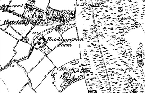
The above (from Old-maps) shows the area from a large scale Ordnance Survey map published from 1884 before the cottages were built. A comparison with modern maps shows that the brick field and adjacent fields have been developed while the strip of common between the brick field and the St Albans to Harpenden Road has become wooded. However I assume it is still common land.
It is also relevant that the map shows that the road is unfenced, and cattle, sheep, etc., driven along the road would have taken advantage of the grazing on either side. In addition the earliest road may not have had a fixed route, and if a part became particularly muddy or difficult travellers would detour round the difficulty, although whether such conditions happened on Harpenden Common is unclear to me. It may well be that the saying "The rolling English drunkard made the rolling English road" relates to the now permanent zigzagging roads over marshy valley bottoms. Sometimes, on some roads, there might be several alternative trackways.
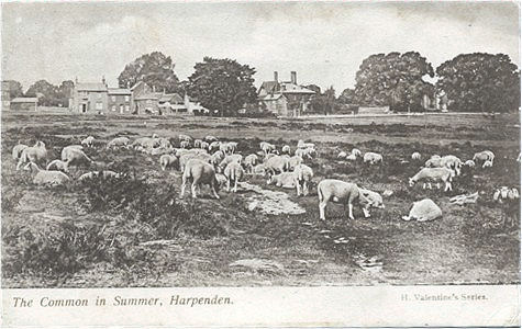
Harpenden Common from a postcard posted in 1904
See Postcards
published by Valentine's Library, Harpenden
This would have changed at the latest with the coming of the turnpike when the line of the road would have become fixed by attempts to give it a firmer surface. Things would have remained comparatively the same until the coming of the motor car - and particularly when the road became a major trunk road out of London, the A6. There would then be an incompatibility between the flocks of sheep which grazed the Common and the increasingly heavy traffic. I have not examined the wood myself and it may well be that the band of trees between the main road and the houses at West Common are no more than natural regeneration due to lack of grazing for something approaching one hundred years. In other parts of Hertfordshire I know one gets hawthorn, followed by silver birch, followed by larger trees, and many nature reserves have to be actively managed to prevent open grassed areas reverting to woodland.
I suspect that West Common Road was originally an informal track along the edge of the Harpenden Common from the former brickworks to Redbourn Lane and the line of the main road has not changed significantly since 1623 (qv). The short length of road from West Common to the main road may also have originally been a cart track across the Common to the brick works. There should be later large scale Ordnance Survey maps than the one above, which show the cottages before later development - say circa 1895 and possible 1920s. If you have not yet seen them try Harpenden Library, if not St Albans Central Library, and if not HALS.
 November, 2005
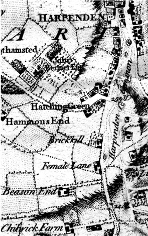
John Wassell (j.wassell @t which.net) writes: The Dury & Andrews map of Hertfordshire recently reprinted by the Hertfordshire Record Society may be of interest. It clearly shows a split in the St Albans road at a pond just north of Beesonend Lane. The main road is to the east of the pond (as it is today) and the loop runs parallel up to "Brickill" then rejoins the main road. The split occurs at a place named "Female Lane" -which I believe is a corruption of "Three Mile Lane" (a term used in connection with the smithy - see Wheathampstead & Harpenden History vol. 4 page 176) and gave access to a blacksmiths shop near the pond. The hollow of this pond (which I believe was called Barton's Pond - see Harpenden & District Local History Society newsletter 48 page 11) is still visible and the line of this lane can be seen as the driveway to Clarence Lodge and the front boundaries of Maple cottages.
I have reproduced the relevant section on the map (from the HRS reprint) and detail shown is remarkable, as individual buildings, etc., are shown.
The map has other names suggesting that the surveyor misheard the local dialect - "Bear Lambs" for Bylands, and "Limerick" for Limbrick, which is also applied to the wrong property!
Misspelt names on early maps are not uncommon, for the reason you have given, and in some cases the spelling used on early Ordnance maps has become the modern "standardised" name!
There is a set of lecture notes on The Road through Harpenden
If you can add to the information given above tell me.
Page updated November 2005
