|
|
Flint Hall, Bushey, 1851 March, 2006 |
|
|
|
Flint Hall, Bushey, 1851 March, 2006 |
|
First have a look at the information on this site describing census returns and you will see that the "19" is not a house number - but the reference number on the schedule (form) for each household.
Next look at the information on Locating Census Addresses on Maps - which shows you how to find where a house was in many cases.
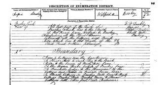
The following show the description of the enumeration district which is unusually detailed so you should not have too much difficulty in finding approximately where the cottages were.
 |
All that part of the parish of Bushey
which lies north of the road from Watford
to Bushey including all the Flint
houses, likewise all the cottages and Brick
Kiln which lies to the south of the said road within the
following boundary:- from two cottages near the Gas
House to Flints Hall to Crooked
Log to the Brick Kiln to
the corner of Merry Hill Lane to the
Manor House, Corner of Bushey
Lane to Burchells Lodge
to the mansion to the cottages and farm in Burness
Farm Lane to Meads cottages
in Bushey Mill Lane to High
cottages Bushey Hall, Bushey Mill
to Horns cottages, Little
Otterspool all inclusive. |
If you also look at the neighbours to your ancestors you will find that the addresses given start at Watford, then Flint Hall, and then Chalk Hill (on modern street maps). The occupations of the neighbours suggests they they were all poor and lived somewhere close to the river in the valley bottom - and it may be that the cottages of Flint Hall have long been demolished as slums..
If you can add to the information given above tell me.
Page created March 2006