 Maps of
Hertfordshire
Maps of
HertfordshirePlaying Card Maps
Robert Morden 1676
Some of the earliest maps of Hertfordshire were printed on playing cards. The first set of such cards was produced by W. Bowes in 1590 and appeared only 13 years after Saxton's map, on which it was based.
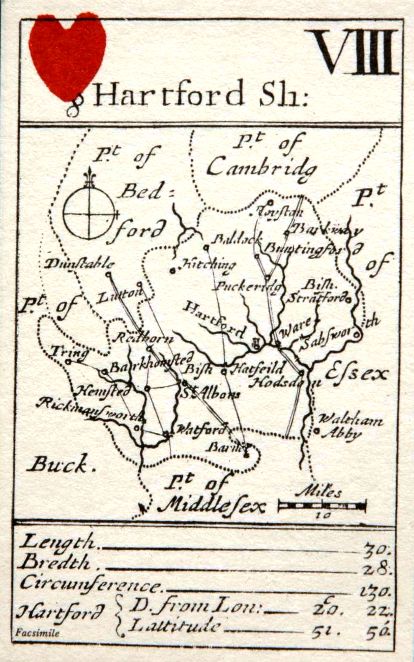
The idea was taken up again in 1676 when Robert Morden published another set of cards, based on Norden, with a map at the scale of 1 mile: 0.05 inch. Printed Maps of Hertfordshire describes it as follows:
This was designed as one of a set of playing cards, each bearing a county map. The choice of counties for the suits is made on a regional basis; the map of Hertfordshire appears on the 8th card of the eastern group. The size of the whole card is 2.3" x 3.7", and the map occupies only the central portion; the number of the card, in both Arabic and roman numerals and the title are engraved in the panel above the map and in the lower panel are statistics.
Each suit of cards was probably engraved on a single plate in the same way as [had been done by Bowes]. Certainly each card was cut from a larger sheet after printing; when the maps were later issued in the form of a pocket atlas, the cards were not printed directly on the pages of the book, but were cut out and stuck down on the blank leaves.
Three editions of the maps are known. The first did not identify the adjoining counties. The second named the counties and the image above is from a 1972 reproduction of this set. Printed Maps of Hertfordshire describes this edition as follows:
Issued in a pack of cards, with the suit-mark stencilled as before. An entry in the Term Catalogue, 22 November 1676 refers to "The fifty-two Counties of England and Wales described in a Pack of Cards ... The Second Edition; whereunto is added the adjacent Counties in each Card, with other amendments" sold by Robert Morden, W. Berry, Robert Green and G. Minikin, all at London addresses.
The third edition had Stevenedge added, and the towns were marked by towers rather than circles. It was issued as a set of playing cards, and in 1680 the maps appeared (without the suit marks) in A pocket book of all the counties of England and Wales.
Also in 1676 William Redmayne issued a set of playing cards with a smaller scale and more crudely drawn map. Between 1717 and 1731 John Lenthall, a London playing card publisher, advertised a set of county playing cards, and the Hertfordshire card is a close copy of Robert Morden's card of 1676.
Robert Morden also published a much larger map of Hertfordshire in 1695.
For more information see Printed Maps of Hertfordshire.
Page created January 2008