|
Dimsdale Building, St Andrews, Hertford, 1841 September, 2010 |
|

Marge {caoftmle @t gmail.com) of Missouri, USA, writes: Jane Saunders is on the 1841 census with her place of abode is listed as Dimsdale's Building. St Andrews, Hertford. I have googled it and get lots of info about the Dimsdale family but nothing that tells what the building was - hospital, workhouse, asylum.
After I had posted this Anthony drew my attention to a document held at HALS (see below) and as a result the discussion about the building's location has been rewritten.
 |
||
|
From Hertford and its Surroundings 1905 (Sorry - no picture of Dimsdales Building available) |
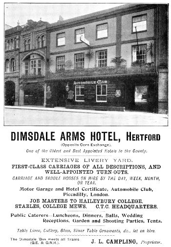
I can understand your problem as if you google for Dimsdale in Hertfordshire you not only come up with many references to Baron Dimsdale and his family, but also places such as the Dimsdale Arms Hotel, Dimsdale House, and Dimsdale Street - but Dimsdale Building references are almost non-existant.
A Detailed look at the Census Return
The easiest way to answer your question is to demonstrate how to get the most out of the census returns. If you look through the enumeration book images for 1841 (and not just at the entry which has the person you are interested in, or a sanitised transcription) you will find a whole series of households in St Andrews Street (the front of the enumeration book says the South Side). This properties along the street are interrupted by references first to a group of houses in Salisbury Court and then some more in Dimsdale Building.
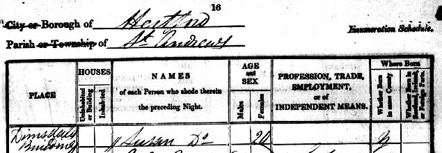
If we look at the actual enumeration book images which include the south side of St Andrews Street we see the first three columns deal with the place and whether the house in occupied or unoccupied. Look down to the line containing the name George Nightingale.
The "Do" (ditto) refers to the words "Dimsdale Building" above, while the mark "1" in the "inhabited" column means that it is the first entry for the next house to be recorded. This house also contains Mary Nightingale. The "//" indicates the end of the house. For the purposes of the census a house would normally have been one or more adjoining rooms with cooking facilities, and a separate entrance. There is no distinction in this matter between a 100 room palace, or a one up and one down hovel. In fact a gypsy caravan would also count as a house for census purposes - but there would normally be a note in the "place" column.
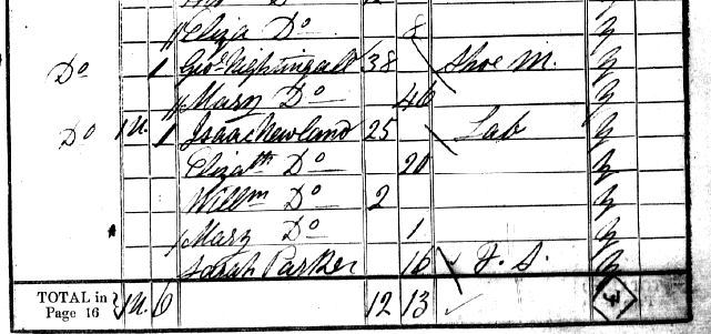
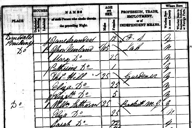
The next line also refers to Dimsdale Building but the "1U" indicates that there was one unoccupied house. (most enumerators then continue on a new line, but this one doesn't). The unoccupied house is followed by another house (indicated by the mark "1" in the inhabited column) occupied by John Newland's family in reverse age order, There is then a single "/" before the name Sarah Parker - to indicate that the house was doubly occupied and that Sarah (and your Jane Saunders on the next page) had a room in the same house. It should be noted that in indexing the census Ancestry has ignored the indications of multiple occupation.
The next house is that of Jhon (Jonathon) Newland with his wife and one child, and they share the house (note single "/") with Thomas Hill and his wife and child.
If you look at the occupations of all the heads of households in Dimsdale Buildings and take into account that several were multiply occupied the conclusion is that the buildings was a series of tenements built for rent to the poorer working class. Virtually all buildings of this nature which were standing in 1841 would have long been demolished as slums.
Ten years later (the 1851 census) none of the people named above were still living there, suggesting a quick turnover of tenants (you moved to better accommodation as soon as you could afford it). At least two of the tenants in the building were on parish relief, In the 1861 census the building was still there, but I couldn't spot it on the 1871 census, possibly indicating it may already have been demolished by this date.
There is one cautionary aspect of the above interpretation, which is why it is always worth looking through the book to see how well the enumerator followed the official guidelines. If a household had resident servants, or boarders/lodgers, they would be listed after the family. Sarah Parker and Jane Saunders were domestic servants - and a check of this enumerator's book shows that in another part of St Andrews Street there was a house where the head of the household was a solicitor - and there were domestic servants in the house - but the enumerator had separated them with a "/" when if they worked for him they were not a separate household living in the house. In practice it is extremely unlikely that Sarah and Jane were the domestic servants of the labourer Isaac Newland, and the enumerator was using "/" ambigiously. This example emphasises why it is important, not only to understand how the books were meant to be completed, but also why you must be aware that not all enumerator's got everything right.
Dimsdale Building may have been somewhat similar to Ballards Buildings at Watford, and there would be similar accommodation for the less well off in most towns. Ballards Buildings are one of the few places of this nature where I have been able to find a picture.
So where was Dimsdale Building. There is a guide Locating Census Addresses on Maps and the following map (from Turnor's History of Hertford) shows St Andrews Street as it was in 1830:
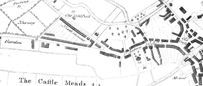
This map shows the main features of the town, and does not show fine detail, such as individual outbuildings, or the irregular backs of buildings facing on to a road. From the census returns we know that Salisbury Court and Dimsdale Building were between the Nursery and Old Cross on the south side of St Andrews Street.
Initially I tried to analyse its position in terms of the 1841 census - but this proved misleading and I have now traced the buildings in the 1841-1891 census returns. An important clue can be found in the 1851 census where the first house is recorded as "Pavitt's Yard alias Dimsdale's Buildings". In the 1881 census it is referred to as Dimsdale Court. It turns out to be close to the Red Lion public house (No 61, St Andrews Street) and is almost certainly the houses numbered 65 to 65m, St Andrews Street in the 1891 census. The Red Lion was demolished when a new road was built in the 1960s, which fixes its position pretty accurately.
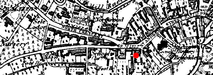
The red dot on this 1880s Ordnance Survey map indicates the approximate position. It is possible that the buildings are the long building running south from beside the dot, marked on the earlier map.
This location fits in with the document at HALS DE/L/T52 "20 messuages called Dimsdale's Buildings, west side of St Andrew Street" 3 items dated 1831 and 1842. These document may contain further information on these buildings. (Thanks to Antony for drawing this to my attention.)
If any pictures of Dimsdale Building survive the place to ask would be HALS - but it may be there is something at the Hertford Museum.
It is perhaps worth mentioning that major institutions, such as the workhouse, had a census book of their own - and it is always very clear when you are dealing with someone from such an institution.