|
Rifle Ranges at Sandridge & St Albans August, 2012 [New Title November 2013] |
|
||||||||


Bill Flentje (billflentje @t btinternet.com) writes from Macclesfield: I am researching the history / locations etc. of rifle ranges in the British Isles. A MoD website concerned with military bye-laws, lists a lapsed (date & text lost) bye-law relating to the 'Chalk Hill Rifle Range' in Hertfordshire. Experience with other 'lapsed and lost' bye-laws tells me that 'Chalk Hill Rifle Range' was likely to have been taken into use during WW1 only, possibly in connection with a large local camp. Do you have any idea as to where this range may have been located?
In my book, The London Gunners come to Town, there are two references to the Chalk Hill rifle range. The first reference reads:
While rifle firing ranges were constructed at Gorhambury and Chalk Hill, St. Albans, there was nowhere near Hemel Hempstead where field guns could be fired and in January the gunners travelled to Salisbury Plain for exercises with live ammunition. Pilditch reported that 7th Brigade "did well, also the 5th and, I believe, the 8th better still. There's one thing about the howitzers, you can't help seeing the big shell-bursts .... The 6th Brigade ... were rather inaccurate."
The context is clearly Royal Field Artillery training in late 1914 and early 1915 by the 2nd London Division (Territorial Force), whose war stations were centred in St Albans. In the above context I believe that the actual reference to Chalk Hill was paraphrasing the text of Major Philip Harold Pilditch's private diary which is in the Imperial War Museum Library, and quoted widely in the book. It is interesting that the Gorhambury range is also on the lapsed bye-law list you mention.
The second reference is discussing what happened when the decision came to prepare for the move to France in March 1915 where I wrote:
A musketry course arranged at Chalk Hill firing range was cancelled.
The source of this is not directly referenced so most likely came from A. Maude's The 47th Division, which was the Divisional History that I used a lot. However it could have come from one of the official War Diaries I consulted - as those for March survive.
So where could the range have been. Neither reference gives a specific address and one would not have been needed in the original document. However there is one very obvious candidate which is shown in this map of Sandridge:
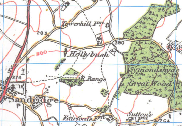
From 1920 O.S. Map (Cassini Historical Map reprint) showing the Sandridge rifle range
Hammonds Farm is the unnamed group of buildings above the word Hollybush
At the time of the First World War records to the Chalk Hill Rifle Range there was already an existing military rifle range a few miles north east of St Albans on Hammonds Farm, Sandridge, which is clearly not the Gorhambury range mentioned above. It was originally constructed sometime after 1895 when the old volunteer firing range in Beech Bottom proved inadequate. It seems certain that its use was continued during the First World War - possibly with some improvements, such as enlarging the butts - and as the above maps show was it still there in 1920. I am not sure how long the range continued in use after the First World War but I am sure my father (who lived on Hammonds Farm from 1922 to 1939) told me there had been a range there, or at least mentioned the Butts. A look at modern Google maps suggest a possible faint line remains among the trees of the wood where the range would have been. I have never seen any explicit reference that this range was ever called "Chalk Hill" but when the butts were constructed they could well have been white from the underlying chalk and it is inconceivable that they were not used in 1914/15 for training purposes.
If you ever find any other documentation which refers to this location I would be very interested. Tracking down temporary First World War place names can be difficult and I am still trying to locate Britons Camp, St Albans, which was clearly a large tented camp which was in existence in the summer of 1915.
Bill responded: I have now studied your information in detail and looking at my records I find that I had already been aware of the ‘Sandridge range’. However, I had not associated it with the ‘Chalk Hill Range’ listed in the MoD Bye-laws. The 1899 map does not show any range here, but that does not mean that none existed here. The survey for the 1899 map could have pre-dated the establishment of a range here in the 1890s. What we do have is a record in the official WO Rifle Range Returns of 1903, which shows a ‘Sandridge’ range as number <E102> (Eastern District), being located about 3m from St Albans, having two targets, possible max. distance of 1000 yards and the option of moving/vanishing targets to 400 yards. It is then shown again in the Returns of 1913 as <E47>, but otherwise almost unchanged. At that point the ‘Chalk Hill Rifle Range’ By-law would have been drawn up, perhaps to be able to stop traffic on the bridle way which crosses the range and as military training was going to be intensified. As you say, maybe the range was also rebuilt at that time with an increase of target numbers. The name ‘Chalk Hill’ puzzles me, but just ahead of the butts lies ‘Chalk Dell Woods’ and it is not a big step from Chalk Dell to Chalk Hill. From the 1920s until the 1940s the OS maps show a 600 y rifle range here (300y on the 1960s map), but this does not necessarily mean that the range remained active all those years.
The only other reference to this range I found in The Times on 18.11.1930: ‘THE HERTFORDSHIRE met at Ayres End yesterday after a sharp white frost. Finding in Langley Wood they ran to Pudlers…..Swinging right-handed over the rifle range they went across Hammond’s Farm, through Chalk Dell to Long Wood, scent failing toward Coleman Green.’
What is interesting is that the 1899 map not only does not mark the range - it also does not mark the wood - suggesting that the wood was deliberately planted round the butt end of the range. I agree that a bye-law could well have been introduced to deal with the right of way that runs past the wood. I was too young (11 months) to remember the range when I lived on Hammonds Farm, but I may well have learnt about it when I visited the area in about 1957. This correspondence has triggered a vague memory that there may have been warning sign on Hammonds Lane near where the footpath would have joined the road.
As to the name - the range is on the side of a definite ridge and Chalk Dell Wood is on another part of the same ridge. However the geology of the area is of clay with flints overlying chalk and despite the underlying chalk the top soil tends to be short of lime! To correct this holes were dug to extract the chalk and spread it on the fields. For instance the 1726 map of Sandridge lists 5 Chalkdell fields, a Chalkdell Wood, and a Chalkdell House Wood while the name Chalkdell was also common in adjacent parishes. (Reconstruction and Measurement of Landscape Change). It may well be that the ridge was (and perhaps still is) known locally as Chalk Hill. It is likely that the land for the range was made available by the Lord of the Manor, Earl Spencer, who owned virtually the whole of Sandridge, and there may be information in the Althrop Estate records (at the Northampton Records Office or at Althrop House)
Clearly the rifle range was in use by the troops early in the First World War as the 8th Battalion Sherwood Foresters was based at Harpenden between 21st August 1914 and mid November, and W.C.C. Weetman reports "We were inspected three times during this period; once at Harpenden by Lieut.-General Sir Ian Hamilton, commanding the Central Force, again on September 29th, by Lord Kitchener in Luton Hoo Park, when we thought we made a very creditable display, and lastly, on October 6th, after we had carried out an attack scheme ending up on the Sandridge Rifle Range, when the Battalion had the honour of marching past Lord Roberts"
On Derelict Places "Ricasso" describes a visit to the former range, with many pictures of the surviving features (and a lot of trees) taken in 2008. He had played there as a child and believed it fell into disuse by the army in the 1950s which fits with. Historic Sandridge (published 1956) records the presence of a rifle range and Historic Sandridge Revisited says they were last used in competition shooting in the 1950s.
 September, 2012
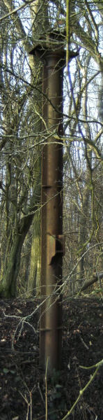
Bill added: As to the ‘Sandridge Range, lingering doubts persist that this really was the ‘Chalk Hill Rifle Range’ as the evidence is too circumstantial. Let me add that I found additional information re- the Sandridge range confirming that post-WW2 it was a 4 target range with wooden windmill type target frames in use (targets rotating around a hub rather than using the sliding target pulley system where they move up and down). The range was then considered for closure (in regards to military use) for safety reasons and its length was already given as 300 yards. Private use thereafter was of course possible. The website with pictures of the range shows a very unusual cast iron (?) column as part of the range furniture of a kind I have never seen before. Do you have any suggestion as to what purpose it may have served?
No ideas about the purpose of the column and one cannot tall if is an isolated feature or perhaps one of a number. There is a flange at the side with holes so perhaps it was part of the frame of building. It also has an earth bank behind it. A visit during the winter to sketch out a plan of the features would put it in context, and might allow it to be identified.
See Shooting Match on Sandridge Rifle Range for an account of a 1907 match on the range
November 2013
Jon has emailed to say: I have a possible alternative site for you to contemplate. There's a part of southern St Albans that was (is?) called Chalk Hill. This is the valley area which is now bridged by the road in from Chiswell Green to the King Harry pub. It is marked as such on the 1949 Provisional OS map, surveyed in the 1930s.
There is a reference in the Herts Advertiser in the middle of 1919 that indicates that the Chalk Hill and Gorhambury ranges are to be shut. Both are said to be in St Michaels parish. Our suggested Chalk Hill area would have been in St Michaels. I can't now locate the details of this Herts Ad article but will keep my eye open.
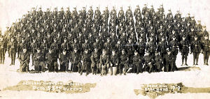
St Albans Library (Y234.18 no. 20) has a group photo of soldiers from D Company, 53rd Queens attending a musketry course at 'Chalk Hill, St Albans'. I can't help feeling that if the site had been in Sandridge, it would have said so.
Looks a possible alternative site - and if it was closed in 1919 it would rule out the Sandridge Range. If the St Michael's site is correct this raises the question of how much the Sandridge range was used during the war - as I can't imagine it went to waste. I suppose it is also possible that the old Beech Bottom range could also have been brought back into use, at least for revolver practice.
Bill replied: I have to admit that I was never happy with the idea of the ‘Sandridge range’ and the ‘Chalk Hill range’ being one and the same. I am grateful to Jon for his additional work as I had not been able to find a ‘Chalk Hill’ in connection with St. Albans, despite searching for it. You made yourself the Chalk Hill – St. Albans connection, when stating on page 142 of ‘The London Gunners come to Town’: ‘While rifle ranges were constructed at Gorhambury and Chalk Hill, St. Albans.’ If it is possible to date the original reference, then, with a bit of luck, the text of the lapsed bye-law may be found in the local paper, my guess is sometime after September 1914, possibly in early 1915. It seems likely that the text was published to alert the local population as to which area would be ‘out of bounds’ during firing and what roads would to be closed.
I have been looking for a ‘Chalk Hill’ for a little longer since we last communicated. There is of course ‘Chalk Hill’ at Oxhey, Watford, a location I ruled out. Then there is ‘Gallows Hill’ at Hertford, which was formerly known as ‘Chalk Hill’’ – again not a site useful in connection with our quest. And finally I looked at Dunstable in regards to the ‘Chalk Hill’ range ... . We are also tracking the North Mimms rifle range location at the moment, in connection with which a number of military postcards were recently for sale on eBay.
The exact location of the Gorhambury rifle range, by the way, also still remains to be traced.
All these ranges were built as emergency measures and were short-lived, i.e. from about 1915 to 1919, confirming the date Jon found in the local paper. I looked at the maps again and with Jon’s guiding notes I found the road known as ‘Chalk Hill’. The range could have been located to the west of the road, firing in NW direction towards Gorhambury. If it was indeed located here, the area will be built over now. However, RAF aerial photo taken in the 1940s may still show a trace of the butts, as we have found elsewhere. I shall try and get access to such a photo and let you know if anything shows.
The ‘Sandridge’ range is likely to have been used during WW1 as well on a smaller scale, as its number of targets was limited. The training of recruits required larger ranges and we recently found a WW1 range at Ripon, which at the time had two large army camps, with 240 targets. It seems that your area saw a number of smaller ranges with possibly 12 – 24 targets each, instead of one large range as at Ripon.
I had not realised the problem of the number of firing positions - which I agree limits the suitability of the Sandridge range. It is important to realise that none of the shooting ranges were in the City of St Albans - which was surrounded by rural parishes. Gorhambury and the suggested site Chalk Hill Range were both in the Parish of St Michael. The reference to the shooting ranges being at St Albans was made in a private war diary by an officer based in Hemel Hempstead who would probably not have bothered (if he actually knew) which of the rural parishes contained the ranges.
 Further
emails from Jon and Bill, with additional information from other members
of the SAHAAS WW1 group, and a photograph from the St Albans Library
showing "General Musketry Course D Coy 53rg Queens, Chalk Hill, St
Albans, 1919" provide more evidence of the location of the Chalk Hill
range. In November 1915 the St Albans Chamber of Commerce was concerned
about the closure of the Hemel Hempstead road when the range was being
used, with a red flag signalling when the road was closed. This would
fit with the range being between Chalk Hill and Bedmond Lane, firing in
a north westerly direction. It would be interesting to know if there was
any surviving evidence of the butts near Bedmond Lane before the housing
estate was built in the area.
Further
emails from Jon and Bill, with additional information from other members
of the SAHAAS WW1 group, and a photograph from the St Albans Library
showing "General Musketry Course D Coy 53rg Queens, Chalk Hill, St
Albans, 1919" provide more evidence of the location of the Chalk Hill
range. In November 1915 the St Albans Chamber of Commerce was concerned
about the closure of the Hemel Hempstead road when the range was being
used, with a red flag signalling when the road was closed. This would
fit with the range being between Chalk Hill and Bedmond Lane, firing in
a north westerly direction. It would be interesting to know if there was
any surviving evidence of the butts near Bedmond Lane before the housing
estate was built in the area.
----------------------------
Jon has now come up with definite proof, from the Herts Advertiser of 10 October, 1914, of where the Gorhambury and Chalk Hill Firing Ranges were:
|
“Notice
Rifle ranges are in course of construction in Gorhambury and at Chalk Hill, S.W. of St Albans and will be in use on and after 15th October, 1914. The Danger
Area of these ranges is bounded by a line from the These
boundaries will be marked by Notice Boards and also
by Red Flags when the Range is in use. Roads and footpaths in the area will be closed while firing is proceeding. Notice is hereby given that it is dangerous to enter the area when the red flags are hoisted. Days and hours
of shooting will be published in the St Albans,
Hertford, Watford, |
July 2015
Mike has just written about investigations relating to the Sandridge range, probably more relevant to the Second World War. He says
My eldest brother remembers seeing army trucks, some trailing field guns going up the old track from the high st to the Butts, this would have been in the 50’s
Also you may be interested to know that I once found (mid 1970s) a dummy mortar round buried in the main backstop mound, (we used to go up there digging bullets from the mound) this was reported and the RLC bomb disposal crew arrived and took it into one of the fields below the butts and blew it up! I had for many years a couple of pieces of shrapnel from it as a keepsake.
There were in fact TWO ranges in the woods, the main one, which had a clear grassy central “ride” from the sheds near the bottom corner extending right up to the butt it’s self, in the woods either side were the slit trenches on both sides at varying distances used for firing.
On the side nearest Fairshot court there was a smaller range (location of the iron post photo) where we used to find 9mm rounds, possibly pistol or automatics maybe.
When it became derelict the sheds at the bottom of the ride were used by Mr Piper, who worked at the wireless station and lived in St Leonards Cres, for keeping chickens, nothing remains of the shed now of course and very little of anything else sadly
September 2016
Alan Stewart has sent the following update on the current state of the former firing range:
I have recently had a walk in the woods where the Sandridge rifle range was situated. There are two visible brick lined target frame pits up by the remnants of the stop butts. One pit is relatively clear, the other is practically filled in with soil and leaves. The two target pits are a distance of, roughly, 50 yards apart. The pit that is clearer looks about 20 yds. long by 4yds. by 10 foot deep. It is difficult to say how long the partially buried target pit might be but the stop butt earthworks which serviced this part of the range were not very high and less complete than the other one. From the cleaner target pit is was possible to walk back along the line of the range and find the remnants of three firing point positions that would have been about 100 / 200 / 300 yds. from the target frames. There is also some brick work debris remains and a metal drain cover at the 300 yd firing point. Nothing longer than the 300yds point seems to remain visible. The area outside the woods is agricultural with a recent tree plantation in the area that would have had the longer distance firing points.
The recently planted trees are part of Heartwood Forest.